 Cape to Cape Expedition
Panama
– May 2003
Objectives
1.
To
confirm that the Darien Gap route is closed to vehicles and to recce the
Carti-El Llano road as a means of accessing the Caribbean coast.
2.
To
ascertain the feasibility of sailing through the Archipelago de San Blas using the
local knowledge of the Kuna Indians to guide us through the reefs and islands.
Personnel:
Steve Burgess and Nicky Spinks
The
Darien
In 1960 the Panama highway terminated at Chepo 52km
east of Panama City. By 1990 the road extended as far as Yaviz – asphalted to
just beyond Lago Bayano. Now in 2003 we found quite a number of vehicles in use
as far as El Real, having been ferried across the Chico and Tuira rivers.
Although a fairly well constructed trail now extends as far as Piji Baisel
officially the use of motor vehicles within the Darien and Los Katios National
Parks is prohibited.
So as we expected (security apart) the overland Darien route is closed to our Land Rovers. We continued on foot as far as Pirre Mountain ridge using Pirre Station as a base.
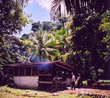
Pierre Station
Although advised against it, the park rangers would
have been happy to guide us as far as Cana Valley some 12 miles from the
Colombia border.
Security is taken seriously – road blocks and I.D.
checks on the highway from Agua Fria eastwards and in rural areas well
protected bunkers on the trails manned by heavily armed police (Panama has no
army) logging our movement. No restrictions were placed on us; where we went
appeared to be at our discretion. Apart from the riverside villages of the
Embara and Wounaan Indians the rangers stations offer the only facilities
within the Darien National Park.
The
El Llano to Carti road
The San Blas Archipelago is a string of over 340
islands on the Panama Caribbean coast. The islands are usually approached by
boat from either Colon, Portobello or by air. Apart from ill defined trails
connecting Embera villages with the coast, Rio Chucunaque and ultimately the
Pan American Highway there is only one road over the mountains.
The 50km road was cut through in 1985 to service a
non existent tourist industry and its non existent hotels. To prevent settlers
poaching Kuna land along the roadside the Kuna established a forest reserve and
the Nusagandi Nature Lodge. As the Kuna don’t have any vehicles and the hotels
haven’t been built the road has remained virtually unused. I hope to use the
road as access to the coast for the Land Rovers. I visited the Land Rover Club
of Panama website and learnt of an “Expedition to the San Blas” which got
halfway along terminating at the Nusagandi Lodge. I needed to find out just how
bad a condition the road was in. The only way for us to do that was to walk it.
The road begins as a narrow track heading north just
outside the village of El Llano 70km east of Panama City. An old car door hangs
from a tree branch, in true Wild West style, with the word Carti and an arrow
scrawled across it.
The first 20km is outside the Kuna Autonomous region
so the ranchers have moved in, cleared the forests, fenced the land and
settled. Apart from some steep gradients the road is quite passable as it
clearly has some use. There is evidence that the road had had a good surface
when built. Strangely at about km22 there is a self contained, solar powered,
microwave operated ITT telephone box ! The road then quite suddenly
deteriorates; the surface washed away down to burnt red earth.
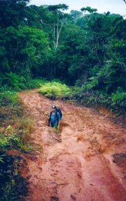
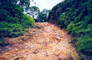
North of Nusagandi
Ascending then descending into deep ravines where
virtually no bridges were built, only culverts for streams to pass through. We
reached Nusagandi Lodge at about km25. The following 20km was made up of narrow
ridge top tracks through dense forest and ravines. All traces of the surface
grade were now lost; the surface now being made up of hard packed red earth.
Any weaknesses gouged out by the torrential rains which fall on these
mountainsides In places the ruts were washed out more than a metre deep. Where
the road builders had encountered rock passage had only been roughly hewn out
leaving sump cracking differential smashing outcrop.
North of Nusagandi
The descent to the narrow coastal plain is steep
(gradients estimated to be 45º) and punctuated by river crossings where the
culverts are completely washed away. One sizeable bridge was constructed over
the Rio Carti Grande but unfortunately the North pier appears to have sunk
considerably, the decking pivoting on the central pier is now elevated some 4
feet above road level ! The river is fordable and the jungle is actively
reclaiming the bridge.
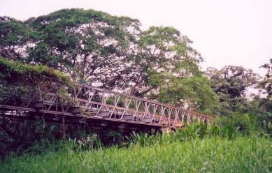
Rio Carti Grande bridge
The last 2 km is through cultivated land mostly rice
and vegetables. The road leads directly onto a short concrete airstrip which in
turn leads to the coral shore, a small police hut and the jetty. Moored up are
canoes to Carti and the islands of the Gulf of San Blas.
All food and provisions were carried on this trek –
water is obviously plentiful. Four different species of snake were encountered
– all treated with respect, not being Central American snake experts. Having
successfully recce’d the roadway we only later heard of some 100m high
waterfalls 8 hours hike off the road. We regretted not having the time to visit
these.
Archipelago
De San Blas
The Kuna:
The islands, over 350 of them are home to the Kuna
Indians. They are one of the seven remaining indigenous groups that inhabit
Panama. They are probably the most politically astute and business minded who
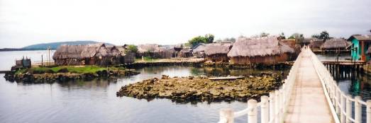
have the most representations in government. Most of the 35,000 that live on
the islands only inhabit about 40 of them packing their huts onto those islands
with barely room to pass between such is their community spirit. All basic
requirements; food, water, fuel and building materials must come from the
mainland (usually not more than 500m away) and sometimes connected with a
raised walkway. They are short stocky people of a particularly happy
disposition who still adhere to many of their ancestral traditions. The women
(who usually control finances in the community) dress in traditional skirt and
blouse decorated with a brightly colour “molar” or patchwork, a black line
drawn from forehead to tip of nose and a gold nose ring. They do not like to be
photographed and great care must be taken not to offend. It is courteous and
sometimes necessary when visiting a community to seek the approval of the
village chiefs or “Sahila’s”
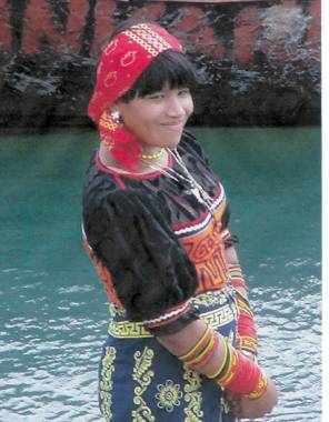
Kuna
Travel: Sea
The canoe is the principal form of transport usually
paddled for fishing but also equipped with outboards for ferrying goods and
people. The outboards power varies from 9 to 90 hp. Hiring canoes seems fairly
easy; you agree verbally the destination (not as easy as it sounds as most
islands have a Kuna, a Spanish and an English name), how long it will take, how
much petrol will be required and the price of the petrol ($3.00/US gallon) with
a port official. Whilst a boatman is being found and the boat prepared you will
be presented with an invoice with all the details on, to pay. Honesty prevails
– we were never overcharged or had to pay for more petrol than was used. We
travelled in this way, island to island, from Carti Ustupo (78º 56’W 9º 25’N) to Mulatupo Sasardi (77º 45’W 9º 55’N).
Columbian merchant ships ply the coast from Turbo to
Colon and back bringing most domestic items and hardware you see for sale in
the shops and purchasing the San Blas principal export commodity – coconuts.
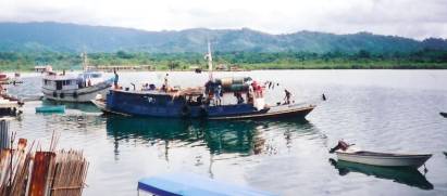
Colombian merchant ships
Travel: Air
The region is well served by three airlines:
Avirtur, Ansa and Aerotaxi (Aeroperlas). All have offices at Alanbrook Airport
in Panama City and with agents in the larger communities. The runways are often
short and squeezed onto the narrow coastal plain between the mountains and the
sea and make for some very interesting landings. Twin Otters seem to be the
most commonly used plane, probably for this reason. A regular timetable is
maintained although flights always seem to be over subscribed.
Accommodation
Accommodation is sparse along the San Blas; most of
the larger communities have either a small hotel or dormitory for visitors.
They are not really geared for foreign tourists but for officials, salesmen and
merchants from the mainland. Nevertheless they were always made available for
us and were basic but adequate.
There are a number of “Eco Lodges” on private
islands which are there purely for the foreign guest.
Mulatupo Sasardi
Weather and Sea Conditions
Statistically the weather is consistently hot and
wet – between 25 and 30ºC all year round with up to 3500mm of rainfall evenly
distributed throughout the year (with perhaps a slight letup in February and
March and again in September / October). Summer in the San Blas (December to
April) is characterised by poor visibility and heavy seas outside the
protective reef. Winter (June to November) on the other hand brings light
variable winds and calm flat seas but small (often less than 2km) squalls with
local winds of up to 45 knots can occur at any time. The San Blas is well south
of the hurricane track. Tidal range is only 30cm. Offshore current prevailing
easterly, with no discernable current inside reef.
Between san Ignacio and Achutupo there is a large
gap in the reef; we encountered a swell of 3-4m which was quite alarming in a
dugout canoe but our boatman remained unperturbed. The San Blas is well charted
in the west but less so in the east. With so much sunken reef and barely visible
coral heads local guides will be essential to negotiate a safe passage.
Findings
The Kuna, although tolerant of travellers passing
through their land and do not hinder or impede them in any way, give the
impression that they don’t mind if you pass them by altogether. The actions and
behaviour of visitors is viewed critically with any misdemeanour or offensive
behaviour reported to the Sahila.
The safe passage of the expedition to reach the road
head at Turbo in Colombia will rely on the help of local boatmen. It is
therefore necessary that the expedition enlist the help guides (possibly Ancon
Expeditions, Panama or similar) to ensure we maintain the highest standards
whilst in the Kuna Yala. The Kuna, while indifferent to visitors, would I hope see
the expedition as a business opportunity and assist it on its way.
Conclusions
The passage of vehicles through the Darien Gap is an
adventure of the past. “Driving” down the Archipelago De Sans Blas will be the
adventure of the future.
Using the Carti to EL Llano road, although a
challenging winch and machete operation will pale into insignificance beside
Siberia and Alaska. That having been said it would be a fine Camel Trophy’esqe
opportunity for “guest volunteers” to experience an expedition of this type.
With rigid compliance to Kuna sensitivity and
securing their assistance I think sailing at least as far as Zapzurro is within
the capability of the vehicle we have at the moment. Up-to-date security
information south of Puerto Obaldia must be sought and also more information on
conditions crossing Golfo De Urabia to Turbo.